The main rule is simple: plan one direction per day. Kachura, Shigar, Khaplu, Deosai and Basho are separate route zones. Trying to combine too many of them in one day usually makes the trip tiring.
How to Read the Skardu Tourist Map?
Skardu city serves as the region’s central base. From here, travelers move toward different valleys and road corridors. Kachura is the easiest lake route; Shigar gives a mix of fort and desert scenery; Khaplu is a longer cultural route; Deosai is seasonal and high-altitude; while Basho is more raw and nature-focused.
Many tourists make the mistake of judging Skardu only by distance. A place may look close on Google Maps, but road conditions, landslides, weather, daylight and jeep tracks can change the full experience. In Skardu, drive time matters more than kilometres.
Before finalizing your plan, check road status, weather, jeep requirements, hotel location and local driver advice. This is especially important for Deosai and Basho, where conditions can change quickly.
Main Entry Routes to Skardu
Most travelers reach Skardu either by air or by road. Your route of arrival also affects how you should plan your first day.
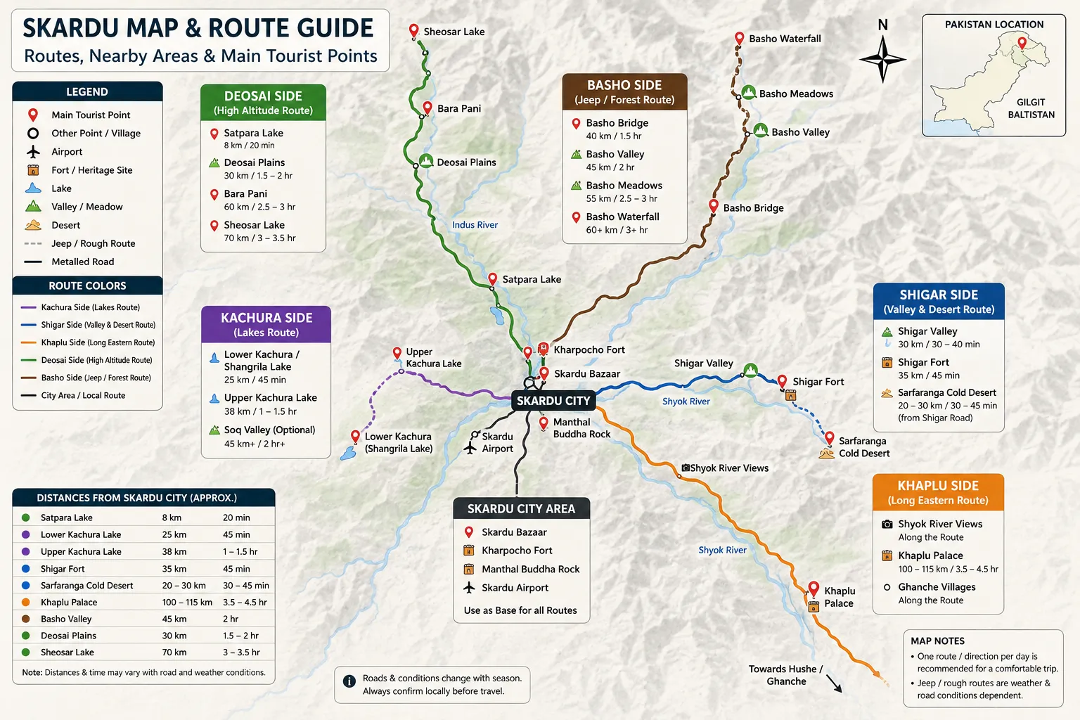
Skardu Map Guide
Islamabad to Skardu by Air
The Islamabad to Skardu flight is the fastest way to reach the region. It usually takes around one hour, but mountain weather can affect flight operations. Morning flights are often preferred because visibility can change later in the day.
Skardu International Airport is outside the main city area. If your hotel is in Skardu city, the transfer is usually simple. If your hotel is near Kachura or Shigar, your first move after landing may already put you closer to a specific route zone.
Keep your arrival day light. Hotel check-in, Skardu Bazaar, Kharpocho Fort or a short lakeside visit is usually enough. For more help with first-day planning, read our Skardu arrival guide.
Islamabad to Skardu by Road
The route from Islamabad usually follows the Karakoram Highway, then connects via the Jaglot–Skardu Road. A common route flow is:
Islamabad → Mansehra/Abbottabad → Besham or Naran side → Chilas → Jaglot → Skardu
The exact route depends on the season. In summer, the Naran–Babusar side may be used if open. In other months, travelers often use the Besham–Dasu–Chilas route. After Jaglot, the road turns toward Skardu through the Indus gorge.
If you are arriving by road, stay in or near Skardu city on your first night rather than pushing toward a distant valley. You can read the full route breakdown in our road to Skardu guide.
Skardu City Area on the Map
Skardu city is the practical base of the valley. It may not be the wildest part of the region, but it is the most useful area for arrivals, departures, food, shopping, transport coordination and short sightseeing.
Main places in and near the city include Skardu Bazaar, Kharpocho Fort, Manthal Buddha Rock, airport access areas, hotels and restaurants.
Skardu Bazaar is useful for snacks, warm clothing, SIM cards, medicine, cash and dry fruit. If you are planning a trip to Deosai or Basho, the bazaar area is also a good place to check jeep availability and ask about current road conditions.
Kharpocho Fort is one of the best places to get a visual sense of Skardu. From this viewpoint, you can see how the valley opens in different directions. Manthal Buddha Rock is another easy cultural stop that fits well into a relaxed city-area plan.
Who Should Stay in Skardu City?
Skardu city is usually the best base for first-time visitors because it offers access to all major directions. It works well for families, elderly travelers and anyone who wants flexible transport, restaurant access and easier day-trip planning.
If your plan includes different routes on different days, the city is usually more practical than staying far inside one valley.
Kachura Side Tourist Points
The Kachura side is one of the easiest sightseeing zones on the Skardu tourist map. It is popular because it gives travelers lakes, soft views and relatively manageable access without requiring a very long drive.
The main tourist points are Lower Kachura Lake, Shangrila Lake, Upper Kachura Lake, Soq Valley and the Kachura village area.
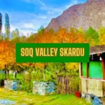
Lower Kachura, often known as Shangrila Lake, is the easier lake stop and works well for families, couples and first-time visitors. Upper Kachura feels quieter and more natural, though walking and access conditions should still be checked locally. Soq Valley can be added if time, vehicle and road access allow.
Kachura works best as a half-day or one-day lake route. Avoid mixing it with Khaplu or Deosai unless your plan is very specific.
Shigar Side Tourist Points
Shigar is one of the most useful route zones for travelers seeking heritage, desert scenery, and valley views without going too far from Skardu city.
The main places on this side include Shigar Valley, Shigar Fort, Sarfaranga Cold Desert, Shigar River viewpoints and nearby village scenery.
Shigar is better planned as a route rather than just one stop. As you move toward Shigar, the landscape changes from city-side roads to river views, desert patches and traditional settlement areas. Shigar Fort is the main cultural highlight, while Sarfaranga Cold Desert is one of the most popular photography points.
A half-day Shigar plan works if you only want the fort and nearby views. A full-day plan is better if you want desert stops, photography breaks, riverside views and a slower valley experience.
Khaplu Side Tourist Points
Khaplu sits on the longer side of the Skardu map. It is not usually a rough jeep route, but it takes time because of the distance.
The main highlights are Khaplu Palace, views of the Shyok River, Ghanche-side villages, and roadside viewpoints. The palace is the main cultural landmark, but the drive itself is also part of the experience. Do not treat Khaplu like a quick stop. If you leave late, rush to the palace and return tired, the route loses its value. Khaplu is best planned as a dedicated full-day route from Skardu.
Families can do Khaplu comfortably if they start early and keep the day focused. Avoid combining Khaplu with Deosai or Basho.
Deosai Side Tourist Points
Deosai is completely different from Kachura, Shigar and Khaplu. It is a high-altitude seasonal route, so weather and road conditions matter more than normal sightseeing distance.
The main points on this side include Satpara Lake, Deosai Plains, Bara Pani, Sheosar Lake and the Deosai–Astore exit route.
Sadpara Lake is often visited before moving higher toward Deosai. The plains are the main attraction, while Sheosar Lake is farther in and should only be included if time, road, and weather conditions allow.
Deosai is best for travelers who can start early, have a full day, are comfortable with altitude and can adjust their plan if the weather changes. Families can visit in season, but children and elderly travelers may feel the altitude more strongly.
Always confirm local road status before departure. For seasonal access, packing and timing advice, read our Deosai seasonal travel guide.
Basho Valley Side
Basho Valley is one of the most rewarding but less simple route zones around Skardu. It is known for forests, meadows, streams and a more natural mountain feel.
The main points include Basho Bridge, Basho Valley, Basho Meadows, Basho Waterfall and local village tracks.
Basho often involves rough sections, narrow tracks and jeep-style movement. A 4×4 is usually recommended depending on the road conditions. This route is best for nature lovers, photographers and travelers who are comfortable with bumpy roads.
Plan a Basho full-day nature route. Do not add it after a heavy Khaplu or Deosai day. If the weather is unstable or your group dislikes rough roads, keep Basho flexible. For a hassle-free journey, book our Basho Valley tour, in which you don’t have to worry about anything; just sit back and relax and enjoy your trip with your loved ones.
Approximate Distance Guide from Skardu City
Distances in Skardu should always be treated as approximate, as hotel location, road conditions, stops, and weather can affect travel time.